 Heres a link http://www.encyclopediaofarkansas.net/encyclopedia/entry-detail.aspx?entryID=2872
If there is a city or county out there that has a Military Memorial, I'll try to visit it. I'll throw in a few military related pictures, websites and stories just to make this even more interesting. The Military Memorials will be mostly from Arkansas since thats where I live. If you have pictures you'd like to send, feel free to do so. If you have a lot of pictures and would like to be an Author just let me know. Comments go to my email viedas@gmail.com.

 Heres a link http://www.encyclopediaofarkansas.net/encyclopedia/entry-detail.aspx?entryID=2872
 A few weeks ago the wife and I went to visit my daughters future In-Laws in Oklahoma. While there David and soon to be Son-in-Law Bryan took me on a tour of the area. The women were having a bridal shower.
 Double click to get the big picture.


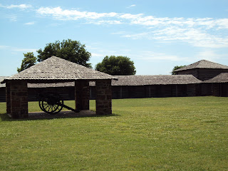
 Ft. Gibson stockade and well 1824. Rich with history and romance. Restored by the Old Fort Club, 1933.


 Cannon aimed at the gate.
 Those are the stockade shackles. Must have been fun in the Oklahoma sun.
 SouthEast corner of the Fort.
 Inside the Fort.
 This picture is looking at the fort from outside the walls.
 If I'm not mistaken this was the enlisted mess outside the fort walls.
 Enlisted mess.
 I have no idea what this once was. It's several hundred yards from any other existing stucture. Actually there were quite a few remnants of old buildings like this. In one area there was a line of foundations which I suppose were barracks or maybe family living quarters, they were also a ways from the existing buildings.
 These were officers quarters.
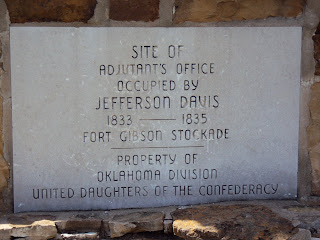
 This plaque is referring to the two chimneys pictured below which is all that survives of the Adjutant Office. I don't know if it was restored and later burned or what.


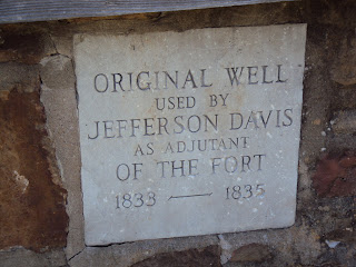
 The well above is next to the Adjutant Office which was where the two chimneys are now.
 Officers quarters in the pic above.
 Officers quarters.
 Memorial to the military men at the new barracks building.
 Barracks for the Seventh United States Infantry. This was a later addition.
 The visitor center and museum, which wasn't open when we were there.
 The East end of the Visitor Center-Museum.
